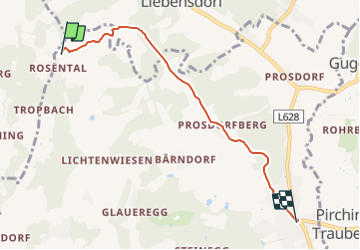
![](/images/other/stat-length.png)
![Tocht Te voet Heiligenkreuz am Waasen - Ermutigungsweg - Photo](https://media.geolcdn.com/t/1900/400/f1086f93-4415-4a1b-9ab1-d539bde46092.jpeg&format=pjpeg&maxdim=2)
Ermutigungsweg
SityTrail - itinéraires balisés pédestres
Tous les sentiers balisés d’Europe GUIDE+
![Lengte](/images/other/stat-length.png)
![Max. hoogte](https://static1.geolcdn.com/siteimages/upload/files/1508320355ic_sort_altitude_max_24dp.png)
![Positief hoogteverschil](https://static1.geolcdn.com/siteimages/upload/files/1508320355ic_sort_den_pos_24dp.png)
![Km-Effort](/images/other/stat-length.png)
![Min. hoogte](https://static1.geolcdn.com/siteimages/upload/files/1508320355ic_sort_altitude_min_24dp.png)
![Negatief hoogteverschil](https://static1.geolcdn.com/siteimages/upload/files/1508320355ic_sort_den_neg_24dp.png)
![Boucle](https://static1.geolcdn.com/siteimages/upload/files/16400158638029165_repeat_loop_refresh_sync_direction_icon.png)
![Te voet](https://static1.geolcdn.com/sitytour/trail-icons/100.png)
1h22
Moeilijkheid : Gemakkelijk
![Scan deze QR-code om de tocht te openen in de SityTrail-applicatie](https://capi.geolives.com/qq0zvz2zws4bq2lad0pu/sitytour/trails/3129965/qr.png?size=200)
Gratisgps-wandelapplicatie
Over ons
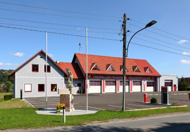
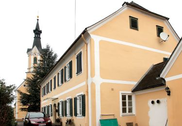
Tocht Te voet van 4,8 km beschikbaar op Stiermarken, Bezirk Leibnitz, Heiligenkreuz am Waasen. Deze tocht wordt voorgesteld door SityTrail - itinéraires balisés pédestres.
Beschrijving
Trail created by Haus der Stille.
Die Stationen sind mit Rolle „POI“ in der Relation, da sie auch räumliche Orientierungspunkte sind.
Symbol: schwarzer Text Ermutigungsweg auf gelben Grund
Website: https://www.haus-der-stille.at/information/projekte/index.php?ID=3120
Plaatsbepaling
Opmerkingen
Wandeltochten in de omgeving
![Tocht Te voet Heiligenkreuz am Waasen - Markusweg - Photo](https://media.geolcdn.com/t/375/260/f755705c-ee28-4cb5-ac80-2b9fd6e1cb5d.jpeg&format=jpg&maxdim=2)
![Te voet Te voet](https://static1.geolcdn.com/sitytour/trail-icons/100.png)
Te voet
![](/images/other/stat-length.png)
![](https://static1.geolcdn.com/siteimages/upload/files/16400158638029165_repeat_loop_refresh_sync_direction_icon.png)
![Tocht Te voet Heiligenkreuz am Waasen - Felgitscher Rundwanderweg - Photo](https://media.geolcdn.com/t/375/260/da7e1891-f51d-4c14-8d19-7274bde81c3a.jpeg&format=jpg&maxdim=2)
![Te voet Te voet](https://static1.geolcdn.com/sitytour/trail-icons/100.png)
Te voet
![](/images/other/stat-length.png)
![](https://static1.geolcdn.com/siteimages/upload/files/16400158638029165_repeat_loop_refresh_sync_direction_icon.png)
![Tocht Te voet Heiligenkreuz am Waasen - Heiligenkreuzer Rundwanderweg - Photo](https://media.geolcdn.com/t/375/260/075011c1-ac4c-4b6e-b63e-aea8abea0bc1.jpeg&format=jpg&maxdim=2)
![Te voet Te voet](https://static1.geolcdn.com/sitytour/trail-icons/100.png)
Te voet
![](/images/other/stat-length.png)
![](https://static1.geolcdn.com/siteimages/upload/files/16400158638029165_repeat_loop_refresh_sync_direction_icon.png)
![Tocht Te voet Fernitz-Mellach - Weg zum Haus der Stille - Photo](https://media.geolcdn.com/t/375/260/f755705c-ee28-4cb5-ac80-2b9fd6e1cb5d.jpeg&format=jpg&maxdim=2)
![Te voet Te voet](https://static1.geolcdn.com/sitytour/trail-icons/100.png)
Te voet
![](/images/other/stat-length.png)
![](https://static1.geolcdn.com/siteimages/upload/files/16400158638029165_repeat_loop_refresh_sync_direction_icon.png)
![Tocht Te voet Hausmannstätten - Rundwanderweg 12 - Photo](https://media.geolcdn.com/t/375/260/9474d2c4-e095-49fb-bb3b-93711f4ee3c6.jpeg&format=jpg&maxdim=2)
![Te voet Te voet](https://static1.geolcdn.com/sitytour/trail-icons/100.png)
Te voet
![](/images/other/stat-length.png)
![](https://static1.geolcdn.com/siteimages/upload/files/16400158638029165_repeat_loop_refresh_sync_direction_icon.png)
![Tocht Te voet Fernitz-Mellach - Josef Krainer Wanderweg - Photo](https://media.geolcdn.com/t/375/260/b6838719-d8df-49af-94f0-23cd81b54269.jpeg&format=jpg&maxdim=2)
![Te voet Te voet](https://static1.geolcdn.com/sitytour/trail-icons/100.png)
Te voet
![](/images/other/stat-length.png)
![](https://static1.geolcdn.com/siteimages/upload/files/16400158638029165_repeat_loop_refresh_sync_direction_icon.png)
![Tocht Te voet Hausmannstätten - Rundwanderweg 11 - Photo](https://media.geolcdn.com/t/375/260/d1a9d739-f7d9-4cf4-baa0-e6b43632651c.jpeg&format=jpg&maxdim=2)
![Te voet Te voet](https://static1.geolcdn.com/sitytour/trail-icons/100.png)
Te voet
![](/images/other/stat-length.png)
![](https://static1.geolcdn.com/siteimages/upload/files/16400158638029165_repeat_loop_refresh_sync_direction_icon.png)
![Tocht Te voet Hausmannstätten - Rundwanderweg 13 - Photo](https://media.geolcdn.com/t/375/260/9474d2c4-e095-49fb-bb3b-93711f4ee3c6.jpeg&format=jpg&maxdim=2)
![Te voet Te voet](https://static1.geolcdn.com/sitytour/trail-icons/100.png)
Te voet
![](/images/other/stat-length.png)
![](https://static1.geolcdn.com/siteimages/upload/files/16400158638029165_repeat_loop_refresh_sync_direction_icon.png)
![Tocht Te voet Hausmannstätten - GSR Südring - Photo](https://media.geolcdn.com/t/375/260/fe3633ef-47ad-4bca-b204-2cb99caee526.jpeg&format=jpg&maxdim=2)
![Te voet Te voet](https://static1.geolcdn.com/sitytour/trail-icons/100.png)
Te voet
![](/images/other/stat-length.png)
![](https://static1.geolcdn.com/siteimages/upload/files/16400158638029165_repeat_loop_refresh_sync_direction_icon.png)